There are several ways to define roads and paths in Kubla Cubed. Starting with a simple footpath the obvious choice is to use the 'Path' element. This allows you to place points along the centre line of a path and set absolute elevations. If you leave a points Z entry blank it will interpolate from its neighbours. After you have created the centre lines you can set a width of the path. Another choice for doing a simple path is to create a berm, this will follow the topography of the centre-line at the relative heights specified.
If you are defining roads you can of course use the path and berm element in the same way. However it is usually better to use the ‘Feature Surface’ for roads that take traffic, with the feature surface you defined the perimeter of the road with a feature surface outline. You can also use and outline within an outline to define a road that completely encloses a space.
There are a few different approaches to take in regard to defining the feature surface depending on the data that is marked on the site plan:
-
Extrapolate Outlines and Contour Lines (Not Recommended) : This works OK but hundreds if not thousands of contour lines are often required to represent a road surface smoothly. The other methods are more efficient. This method is only really used if the contours are defined already in CAD or are the only thing marked on the site plan.
-
Extrapolate Outline and Break Lines (Quick) :Another approach for defining roads with a feature surface which is quite quick is to define the centre line with a break line and then the road perimeter with an extrapolate outline. This will create a road surface that is flat which isn’t optimal as most roads have a camber.
-
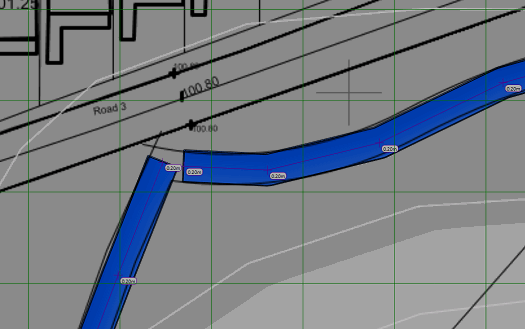
Varying Levels Outlines and Break Lines (Recommended) : The recommended approach for defining a road surface is to define a centre line with a break line and then use a varying level outline to input the levels of the road perimeter. This allows you to define the camber of the road which is often desirable to get the most accurate surface. Sometimes there is no centre line marked on a site plan in which case just using a varying level outline without the centre line is the best option.
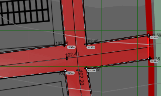
We have discussed the road surface but often you will also want to complete footpaths down the sides of roads for pedestrian or bicycle traffic. This can be achieved by creating separate feature surfaces below the main road surface in the calculation order for the pavements. If using the ‘offset method’ of subgrade adjustment you can then offset the road surface and footpaths separately. In order to avoid having to snap the side of the pavements to the sides of the roads exactly it is best to define the footpaths in the same phase as the road surface. If the footpaths are lower in the calculation order then you can tuck the roads underneath the footpaths. In the areas of intersection the footpaths will override the road elevations and it will create a smooth join between the two.

|
Roads and Paths A demonstration of the three methods that can be used to define roads and paths, using Kubla Cubed. |