Contour lines (or isolines) are used to define lines on the terrain with a fixed elevation.
When tracing contour lines manually, a fixed elevation is added after completing the line. However, when extracting contours from a PDF or import from a flattened CAD file, there are no Z (level) values within the data, therefore you need to add these elevations. It is acknowledged that this can be time consuming, so the SME tool was built to set the elevations of a group of contour lines, which should make the process considerably faster!
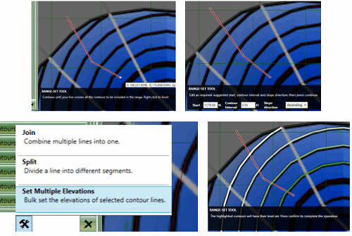
The SME tool works quite differently from the Join and Split with regards to selection. With the SME tool chosen from the menu, place a point just before the first line to be included. Then move the mouse and subsequently place a second point beyond the first and second line in the range. Then either right click to finish or continue moving and clicking to add a multi point line. Where the line is drawn will identify the lines to be included. Once the range line has been created (after right click) the start elevation, contour interval and slope direction (ascending/descending) can be set. Once these values have been edited as required, press 'Continue'. A preview will then highlight the contours lines with a gradient green shading to highlight the elevation differences. If the preview is acceptable, press 'Finish' to accept the proposed changes.
-
Select the SME tool from the menu
-
Define the Range: Using your mouse left button, draw a line from just before the first contour, to the final contour, and ensure your line is intersecting all of the contours that are in the group you want to set. Lift the left button and then press down again if you want to have a range line that is not straight
-
Right click to finish the line.
-
Set the 'Start' (elevation value of the first contour line) e.g. 200. Then add the 'Contour Interval' (difference between each contour e.g. 1) and choose whether difference is ascending or descending.
-
Press 'Finish' button

Above (clockwise from bottom left): SME tool location, drawing the range, accepting/editing defaults, preview of changes.
Closed lines are supported. If the operation needs to be cancelled, click on the 'X' in the top right of the black strip along the bottom, will cancel the SME operation.
Defaults for the Starting elevation, contour interval and whether the slope is ascending/descending are set based on the first two contour lines under the selection.