How to Calculate Stockpile Volumes, with Free Software
Stockpiles are used in construction and mining to temporarily store bulk materials. You will often see large stockpiles containing a variety of materials near construction sites, mines and ports. Just like any other type of stock, it is important to know how much of it you have. It may be that you need to use your stock material for future construction, or, if you want to remove it, you will need to calculate how many truck journeys are required to remove it from the site.
Accurate stockpile volume estimates are critical for managing costs.
In this article, we look at methods for calculating stockpile volumes (using online tools) that assume the stockpile is a somewhat simple geometric form, e.g a cone. For more complicated scenarios, we will look at calculating stockpiles using survey data and free software tools (in this case Kubla Cubed Lite).
A lot of this content is also covered in the following video :
What Methods are Available to Calculate Stockpile Volumes?
There are many different ways to calculate a stockpile. The cheapest and quickest way is to find someone with experience to eyeball the pile and ‘hazard a guess’. After you’ve done that, it is a good idea to start with some more technical approaches.
Approximate to Simple Geometric Shapes
Due to the way that they are constructed, stockpiles often conform to a standard shape. When we approximate the stockpile to that shape, we can use some basic measurements from the stockpile (height, diameter of base etc.) and a known mathematical formula to calculate the volume. You can either do this task the old fashioned way with a calculator, or use spreadsheets, or some online tools.
Here are a couple of examples of online calculators, which (with your data) can be used to calculate the volume and mass of both coned and rectangular stockpiles.
https://www.engineeringtoolbox.com/stockpile-volume-d_1532.html
https://www.spikevm.com/calculators/excavation/volume-pile-yards.php
The above tools are useful when the stockpile is a standard geometric form. However, to calculate a more accurate total volume, you will need to complete a survey of your stockpile.
Complete a survey of the Stockpile
If approximating to a simple geometric shape is not considered satisfactory, then an alternative approach is to complete a survey of the pile. You can complete your survey using ground based surveying equipment, although it’s now becoming more common to use drones (UAV’s).
It is possible to calculate the stockpile volume using graph paper and plotting the points. However, these days it is much faster to use software for this task. Below we look at one approach using Kubla Cubed.
Getting Started with Kubla Cubed
To start with, download and install the latest version of Kubla Cubed Lite. It is free to download and use commercially, plus there is no time limit. Some features of the professional version are restricted in the Lite version, however, we do not need those for this task.
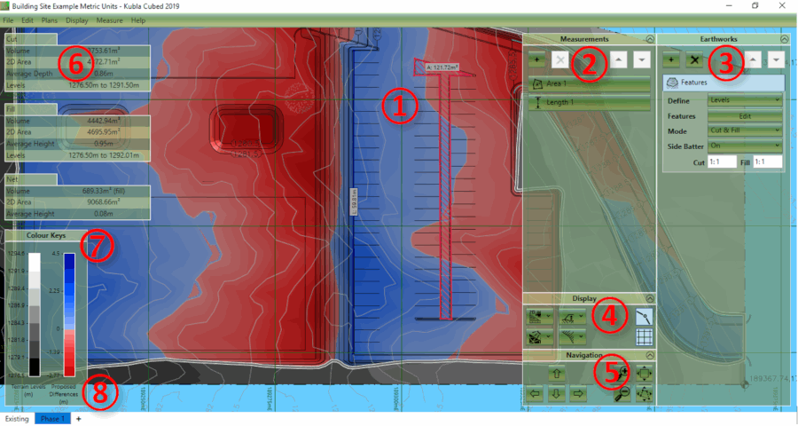
The different elements of the Kubla Cubed (above) user interface are briefly described below:
① Design Area – This is the main display, where the existing ground and the proposed earthworks will be displayed.
② Measurements Panel – This panel is used for adding, removing and editing the measurement elements, e.g. lengths, areas, counts.
③ Earthworks Panel – This panel is used for adding, removing and editing the earthworks elements, which are combined together to create a proposed surface.
④ Display Panel – This panel is used for changing various display options, e.g. camera controls, lighting and grid lines.
⑤ Navigation Panel – The controls in this panel can be used for zooming, panning and rotating (in 3D) the views.
⑥ The Results Panel – The results panel shows an overview (cut, fill, net) of the earthworks estimation for the current phase. A more detailed analysis can be produced in a report or spreadsheet.
⑦ The Colour Keys – These colour keys show the shading which is used to display the existing and proposed topography.
⑧ Construction Phases – At the bottom of the screen, the first tab shows the existing ground; subsequent tabs show phases of proposed earthworks.
Notes on Display Units : Before starting, it is worth making sure the display units are set the same as your survey points file. Kubla Cubed can display either metric or imperial (English) units. These will initially be set to a default value depending on the regional settings of the computer. However, this setting should be checked by clicking Measure in the menu bar and then Display Units.
After the display units are set correctly, it is a good idea to first familiarise yourself with the basic layout.
Importing the Survey Point File (.CSV, .XYZ, .XLS)
Once the survey of your stockpile is complete, either using ground survey equipment or a drone (UAV), you should have a txt file containing all the points.
To import your point file, go to the Ground Panel and click on the ‘+’ button. Then select Feature Surface.
After that, select the Points tab on the far right. At the bottom there are two ‘+’ buttons; one for adding points manually and another with a file icon for adding points from a file. Click on the one to Add from File.
You will then see the screen below.
You can now check and amend the file format settings so that the X,Y,Z columns in your file are processed into the table correctly.
What if I have my points in a CAD File or PDF Site Plan?
You can also import points from CAD or trace them from a site plan PDF or image file. There is more information about this on our tutorials page .

Once you’re happy with the file format, click OK and the points will then show in your project. You’re now ready to add an Outline which will triangulate the data to form your Existing Surface.
To do this, click Outline tab, then ‘+’ Pencil and then choose between the Automatic or Draw outlines. Automatic outlines are generated by the software, and will use the points you have added, to create an outline that is shrink wrapped around the points. Alternatively, you can draw an extrapolate outline yourself around the boundary of your existing ground surface. This can be useful if you want to extend out the surface area.
Checking the Scale : It is critical in this exercise that the points are imported with the correct scale. So, after importing, it is worth checking the scale with the ‘Quick Measure Tool’. To activate the quick measure tool hover your mouse over the point you want to measure from and press the M key. Whilst keeping the M key pressed, move the mouse to the next point. Then a line between the two will be displayed with a label showing the distance. The measure tool can be used in any window where project data is displayed.
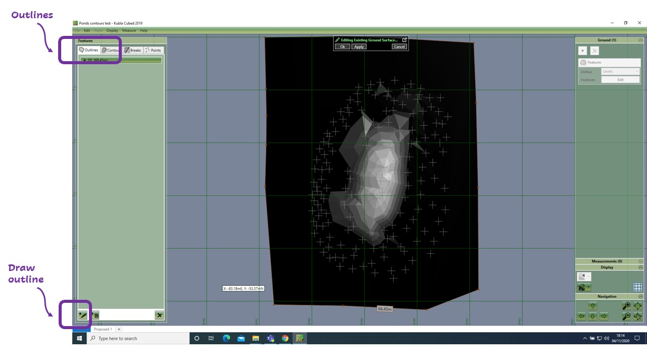
These screenshots show the 2D (above) and 3D (below) visualisation of the stockpile. There is a video to learn about general navigation in Kubla Cubed here.
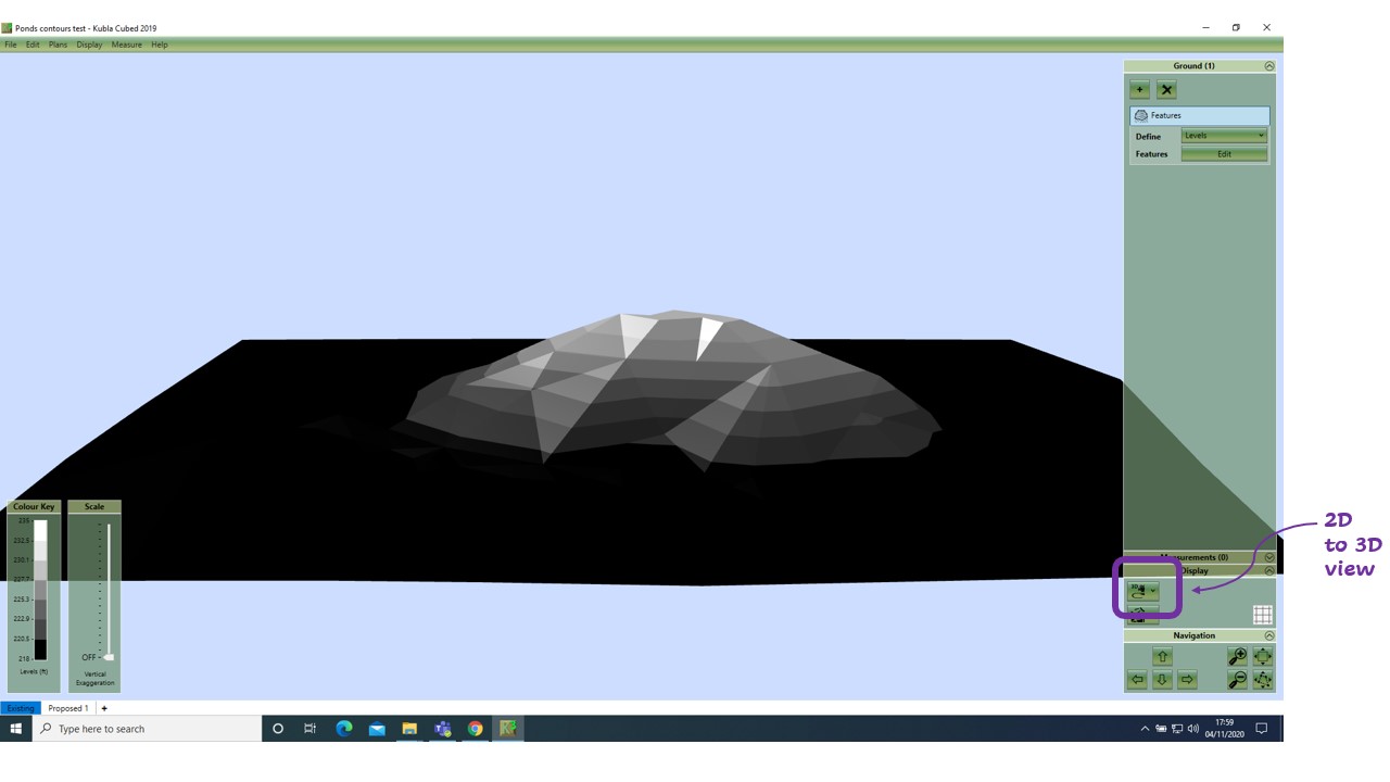
How do I Calculate the Volume of the Stockpile?
With the existing surface now complete, you can click onto the Proposed tab at the bottom of the screen.
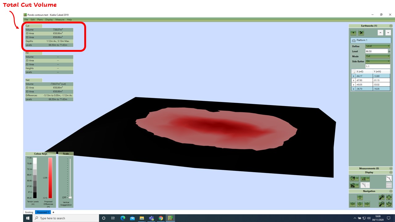
Using the Platform element, you can draw a boundary around your stockpile base and adjust the level of the platform to the elevation level at the base. To do this, in the Earthworks panel, click ‘+’, and then Platform, then trace around your stockpile. Once complete, in the Earthworks panel you will see properties listed under the Platform 1. Here change the Mode to Cut.
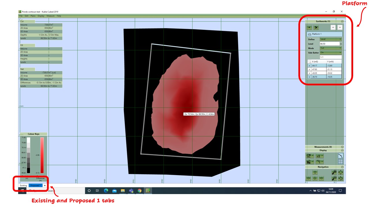
These screenshots show the 2D (above) and 3D (below) visualisation of the stockpile cut, leaving a flat surface where it once was. In this scenario the stockpile survey becomes the ‘existing surface’ and a flat area is the ‘proposed’. We are asking the program to give us the ‘cut’ if we just excavate the stockpile to a given level with a given perimeter.
The stockpile elevations defined in the existing will now show reduced to the Platform level, hence you will see a cut volume (top left-hand corner) which represents the volume of the stockpile.
And that’s it. As easy as that, now you can calculate stockpile volumes with free software tools.
Good luck with your projects!
Further Resources
- Watch the stockpile video which covers similar topics.
- Download Kubla Cubed 2019 Lite the software used in this video. It also can be used to calculate building pad volumes, ponds, basements etc…
- Buy Kubla Cubed 2019 Professional the easy to use earthworks estimation (cut\fill) program.
- Tutorial and Walk-through videos cover a broad range of topics related to using Kubla Cubed for volumetric analysis.
- More articles
